Whether you're sailing past Aswan’s granite islands or studying the boundaries of ancient Nubia, The Cataracts of the Nile whisper stories of a river that refuses to be tamed.
Post Introduction
Whether you're sailing past Aswan’s granite islands or studying the boundaries of ancient Nubia, The Cataracts of the Nile whisper stories of a river that refuses to be tamed.
Post Content
The Nile River, the lifeblood of Egypt, is often romanticized for its serenity, history, and spiritual significance. But there’s a lesser-known feature along its southern stretch that contrasts sharply with the image of a calm, meandering river—the Cataracts of the Nile. These dramatic geological formations disrupt the river’s otherwise smooth flow, creating impassable sections that have shaped Egypt’s history, economy, and geopolitical boundaries for centuries.
So, what are the Cataracts of the Nile in Egypt, and why do they matter? Contrary to medical associations with the word “cataract,” in this context, it refers to a series of rocky rapids and whitewater stretches that break up the river in southern Egypt and northern Sudan. These are not waterfalls in the traditional sense but areas where massive boulders and rocky islands force the water into violent turbulence.
Historically, the cataracts marked both physical and cultural barriers—natural boundaries that played pivotal roles in trade, defense, and the rise of Nubian and Pharaonic civilizations. The term "cataract" itself, derived from the Greek kataraktēs (meaning "waterfall" or "downrush"), was adopted by classical historians who witnessed the Nile’s thunderous energy in these regions.
In this article, we’ll explore where the Nile’s cataracts are located, why they formed, and how they influenced Egyptian history, navigation, and regional politics. Whether you’re a traveler, historian, or simply curious, this deep dive will take you straight into the heart of the Nile’s wildest stretches.
Did you also know that you can learn about Temple of Seti
by just one click
The Cataracts of the Nile are sections where the river's flow is interrupted by granite outcroppings, rocky islets, and shallow rapids. These features create areas of intense turbulence that were historically impassable by large boats or commercial vessels.
Rather than vertical waterfalls, these cataracts form horizontal obstacles, turning wide sections of the river into maze-like labyrinths of rocks, currents, and eddies. The word “cataract” in the context of the Nile refers more to navigational hazards than scenic falls.
Did you also know that you can learn about Dendera Temple
by just one click
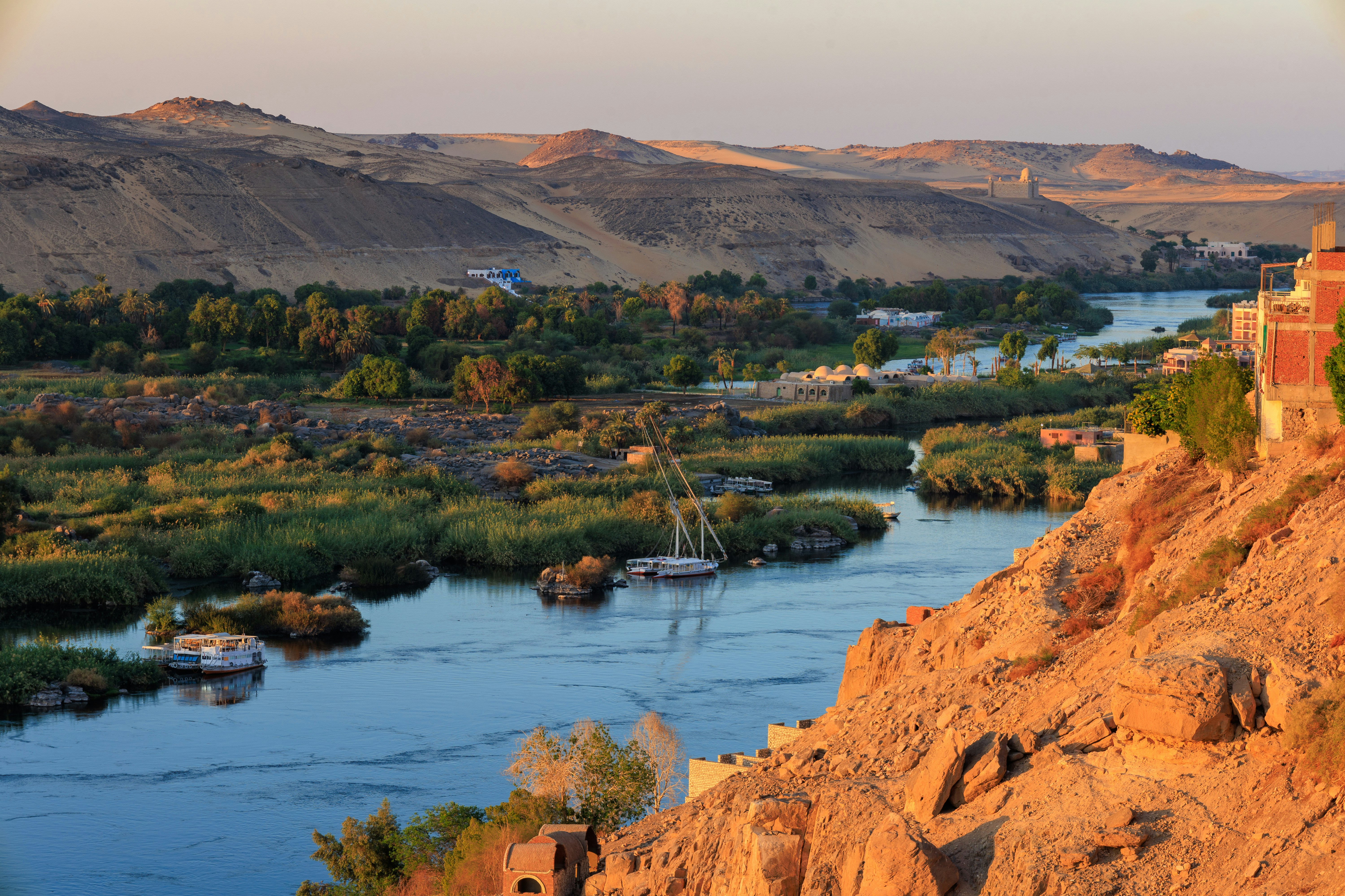
There are six recognized cataracts of the Nile, most of which lie in modern-day Sudan. However, the First Cataract, located near Aswan in southern Egypt, is the most famous and historically significant within Egyptian borders.
Here's a breakdown of the cataracts:
First Cataract – Aswan, Egypt
Located just south of the modern city of Aswan, this cataract once marked the southern border of ancient Egypt. It was a strategic military point and a major center for trade with Nubia.
Second Cataract – Wadi Halfa, Sudan
Submerged in part by Lake Nasser, this cataract was once one of the most difficult to navigate due to its broad and rocky terrain.
Third Cataract – Tombos, Sudan
Known for its clusters of granite boulders and ancient temples nearby.
Fourth Cataract – Meroë region, Sudan
Mostly submerged by the Merowe Dam. This region was once rich in archaeological artifacts.
Fifth Cataract – Near Karima, Sudan
A series of smaller rapids rather than a large cataract, but still significant in disrupting navigation.
Sixth Cataract – Just north of Khartoum, Sudan
The last cataract before the river merges into a single channel toward northern Sudan and Egypt.
The First Cataract remains the most accessible and historically referenced, making it a key destination for tourists exploring southern Egypt.
Trust Cairo Top Travel Companies for Safe, Seamless Egypt Travel
The Nile’s cataracts are a product of tectonic uplift and erosion. As the river carved its way north from the Ethiopian Highlands, it encountered regions of igneous rock, particularly granite, that resisted erosion. Over millions of years, these rocks fractured, forming sharp ridges, boulders, and islands.
The difference in elevation and river gradient caused the water to rush through narrow channels, producing rapid currents and whitewater. Unlike smooth riverbanks upstream, these regions turned into natural mazes of turbulence, especially during the annual Nile floods.
The First Cataract served as Egypt’s southern frontier for thousands of years. Beyond this point lay Nubia, a region rich in gold, ivory, and exotic goods. The cataract acted as a defensive barrier against southern incursions, as well as a checkpoint for goods entering Egypt.
During various periods, Egypt expanded southward, controlling lands as far as the Fourth Cataract, especially during the New Kingdom. Conversely, the Kushite Kingdom of Nubia once ruled Egypt during the 25th Dynasty, illustrating the shifting power dynamics between civilizations straddling these geological boundaries.
Navigating the Nile’s cataracts has always been a logistical nightmare. Ancient Egyptians relied on portage, dragging boats around the rocks on land. This made Aswan a crucial hub, where goods and people paused before continuing their journey.
Even in modern times, the cataracts remain an obstacle to full navigation along the Nile. Projects like the Aswan High Dam and Lake Nasser have submerged some cataract regions, but full control over navigation is still elusive.
Modern engineering has tamed parts of the Nile, but not without environmental and cultural costs. Entire villages and archaeological sites were relocated due to damming efforts, particularly around the Second Cataract.
Today, the First Cataract near Aswan is a major tourist attraction. Visitors can explore:
Environmental Impact of Damming the Cataracts
What are the cataracts of the Nile?
They’re rocky sections of the Nile River marked by boulders, rapids, and whitewater that obstruct navigation.
How many cataracts are on the Nile River?
There are six major cataracts between Aswan, Egypt, and Khartoum, Sudan.
Why is the First Cataract important?
It served as a natural border and military stronghold in ancient Egypt, controlling trade with Nubia.
Are there waterfalls in the Nile?
Not traditional waterfalls, but cataracts with violent rapids and shallow, fast-flowing sections.
Can tourists visit the Nile cataracts?
Yes, particularly the First Cataract near Aswan, which is a scenic and culturally rich destination.
The Cataracts of the Nile in Egypt aren’t just geological features—they’re historical markers, cultural crossroads, and enduring symbols of the river’s raw power. From shaping the southern frontier of ancient Egypt to challenging modern engineering, these cataracts continue to influence the region’s identity and future.
Whether you're sailing past Aswan’s granite islands or experiencing the river through a 3 nights Nile Cruise, or planning a cultural journey like the 8 Days Egypt Luxury Tour, the cataracts whisper stories of a river that refuses to be tamed. And in those wild, foaming stretches of the Nile, Egypt’s soul still surges.


